Platform Architecture

Engineering at the
edge of autonomous flight.

elipptic5G is built on three integrated layers: a purpose-designed UAV, a mobile ground control system, and a cloud-based AI post-processing engine — each engineered for reliability in demanding field conditions.

elipptic5G UAV Specifications

A carbon-fibre hexacopter engineered for industrial site inspection — with survey-grade RTK positioning, GoPro Hero 12 imaging, and a flight endurance that covers 100 hectares in a single autonomous mission.

The airframe integrates 5G SimHAT for live streaming, FHSS radio at 5.8GHz for interference-resistant control, RTK at 2.4GHz with NTRIP for centimetre-accurate positioning, and a Remote ID module for regulatory compliance.

ConfigurationMulti-copter (Hexacopter) · VTOL
Flight ModesFully Autonomous · Mapping · Surveying · Manual
Flight Time>40 minutes
Max Range2 km (radio line of sight)
Max Altitude1,000 ft AGL
Weight6.5 kg
Flying Speed5 m/sec
Area CoverageUp to 100 ha per flight at 3.5cm GSD
Launch & RecoveryVertical takeoff / landing · 5m × 5m footprint
Wind ResistanceUp to 15 m/s
Temperature Range–20°C to +60°C
CameraGoPro Hero 12 Black · 4K 120fps · 8K Photo
PositioningSurvey-grade RTK · NTRIP verified · GNSS multi-constellation
Material3K Carbon Fibre airframe
Ground ControlelippticMOBILE app · Photogrammetry mission planning · Live map

End-to-End Integration

The elipptic5G system is a containerised, microservices-based architecture — deployable on local servers or in the cloud. Every layer communicates securely via token-authenticated APIs.
elippticMOBILE ground control app

elippticMOBILE

Mission planning app. Connects to the UAV via 5.8GHz FHSS AP link. Executes autonomous waypoints, captures telemetry, and transfers data to the server without human intervention.

elippticENGINE

Cloud or on-premise SaaS post-processing. Runs 3D photogrammetry, ML object detection, and auto-reporting. MySQL database with indexed search, map overlay, and secure token access control.

Multi-User Dashboard

Role-based portal access for multiple simultaneous users. Clients access reports, 3D models, and mission history through secure, user-friendly interfaces on web or mobile.

Real ENGINE Output — AI Detection in the Field
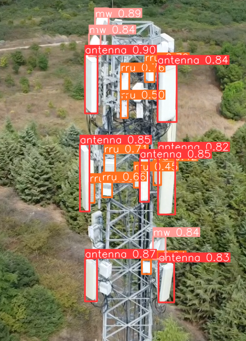
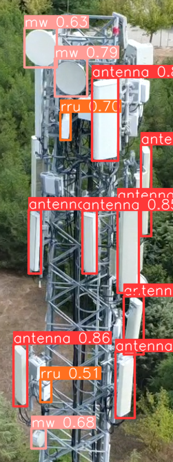
AI object detection — antenna, RRU and MW identified on cell tower
TELECOM DETECTION

CNN/SSD identifies antennas, RRUs and microwave dishes with confidence scores in real field imagery.

Multi-object detection — dense cell tower with bounding boxes
MULTI-OBJECT CLASSIFICATION

Dense tower surveys with simultaneous detection across antenna, RRU and MW classes — all in one pass.

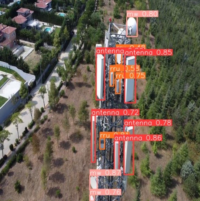
Aerial AI detection — cell tower with bounding boxes from drone survey
AERIAL DETECTION OUTPUT

Real field output: aerial perspective with AI bounding boxes mapped over the site, showing equipment and surrounding terrain.

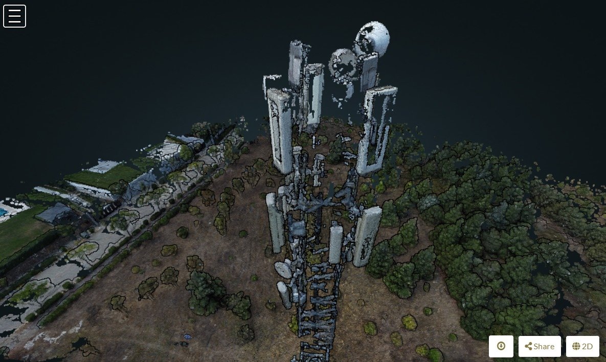
3D photogrammetric model of cell tower site generated by elippticENGINE
3D PHOTOGRAMMETRY OUTPUT

Real ENGINE output: full photogrammetric 3D reconstruction of a cell tower site with surrounding landscape, ready for BIM and structural analysis.

AI models purpose-trained for industrial inspection.

All AI models are developed and trained in-house by 3Cell's engineering team, using proprietary annotated datasets supplemented with open-source image libraries. Models are updated continuously as new field data is collected.

Telecom Object Detection

Two-stage pipeline using SIFT feature extraction followed by CNN classification. Identifies antennas, RRUs, MWs, MHAs, and structural defects with 95% accuracy.

CNNSSDSIFT10k+ images93% antenna model accuracy

Fire & Smoke Detection

Real-time CNN/SSD detection trained on 15,000+ annotated images across diverse environmental conditions — daylight, low-light, and high-contrast backgrounds.

CNNSSD97% accuracy15k+ imagesReal-time

Powerline Segmentation

U-Net architecture for pixel-level segmentation — the standard for dense prediction tasks. Achieves 93% segmentation accuracy across 12,000+ training images.

U-NetSemantic Segmentation93% accuracy12k+ images

Vehicle & Person Detection

Multi-class CNN/SSD trained on 50,000+ images. Processes live aerial footage at 30 frames per second — achieving 95% vehicle and 93% person detection accuracy.

CNNSSD30fps50k+ imagesMulti-class

Secure. Licensed. Interference-free.

All communication frequencies are licensed and encrypted. The FHSS switching mechanism makes interception cryptographically impractical. Remote ID ensures full regulatory compliance with aviation authorities.

5.8 GHz

Control Link (FHSS)

Access Point link between elippticMOBILE and the UAV. Frequency-Hopping Spread Spectrum switches frequencies ~60 times per second — preventing interception and ensuring no interference with 5G base stations. Licensed and encrypted.

2.4 GHz

RTK Positioning (NTRIP)

Real-time Kinematic positioning module for centimetre-accurate geo-tagging. NTRIP protocol enables secondary verification via base stations. Supports GPS, GLONASS, Beidou, GALILEO, and QZSS constellations. Data is licensed and encrypted.

5G

Live Data & Streaming

Integrated 5G SimHAT (LTE Cat-4, multi-band) enables low-latency HD video streaming and real-time mission data telemetry. Supports LTE-FDD, LTE-TDD, and fallback to 3G/2G. Ideal for remote area operations.

RID

Remote ID Module

Digital drone identification enabling aviation authorities (including the UK CAA) to track and verify the system in real time. Ensures full regulatory compliance for operations in controlled airspace. Supports mandatory registration procedures.

Ground control in your hands — live from the sky.

Plan missions, monitor live telemetry, view the drone's camera feed in real time, and transfer captured data to elippticENGINE — all from a single app. No pilot required once the mission is launched.

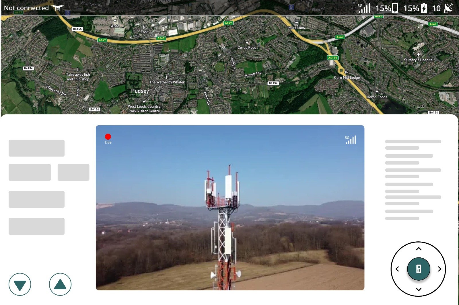
elippticMOBILE — live map with 5G drone camera feed showing cell tower inspection
LIVE MAP

Satellite overlay with real-time drone position, flight path, and waypoint visualisation.

LIVE 5G CAMERA

HD drone camera streamed in real time over 5G. Field teams see exactly what the drone sees, instantly.

MISSION CONTROL

Upload waypoints, set altitude, trigger autonomous take-off, and monitor battery and signal strength.

The cloud platform behind
every report.

elippticENGINE is the SaaS post-processing brain of the platform. It receives flight data from elippticMOBILE, runs photogrammetry and ML pipelines in parallel, and serves structured reports and 3D models to authorised users.

3D Photogrammetry

Generates full 3D models from flight imagery using photogrammetric reconstruction. Outputs include point clouds, mesh models, and 360° structural views — ready for BIM integration.

ML Object Detection Pipeline

Runs trained CNN/SSD or U-Net models against captured imagery. Detects, counts, and classifies objects across 80+ categories with configurable confidence thresholds.

Automated Report Generation

Produces customisable inspection reports with coordinate data, equipment inventories, flagged anomalies, and map overlays — automatically, without analyst intervention.

Secure Multi-User Access

Token-based authentication with role-level permissions. MySQL backend with indexed search. Deployable on 3Cell cloud infrastructure or on-premise client servers.

elippticENGINE · Dashboard
Active missions 3 Live
3D models processed 142 Indexed
Reports generated 286 Delivered
Objects detected (30d) 18,420 Classified
AI model accuracy 95% Active
Active users 12 Secured
Deployment Options
3Cell Cloud On-Premise Hybrid

Want to go deeper
under the hood?

Our engineering team is happy to discuss specific technical requirements, integration constraints, or custom AI model development.

Talk to Engineering → contact@threecell.co.uk