AI-Powered Vertical Solutions

Built for every
critical industry.

elipptic5G's AI models are purpose-trained for each industry — delivering inspection-grade accuracy where traditional methods are too risky, too slow, or too expensive.

Six industries. One platform.

Telecommunications

Cell Tower Inspection & 3D Site Survey

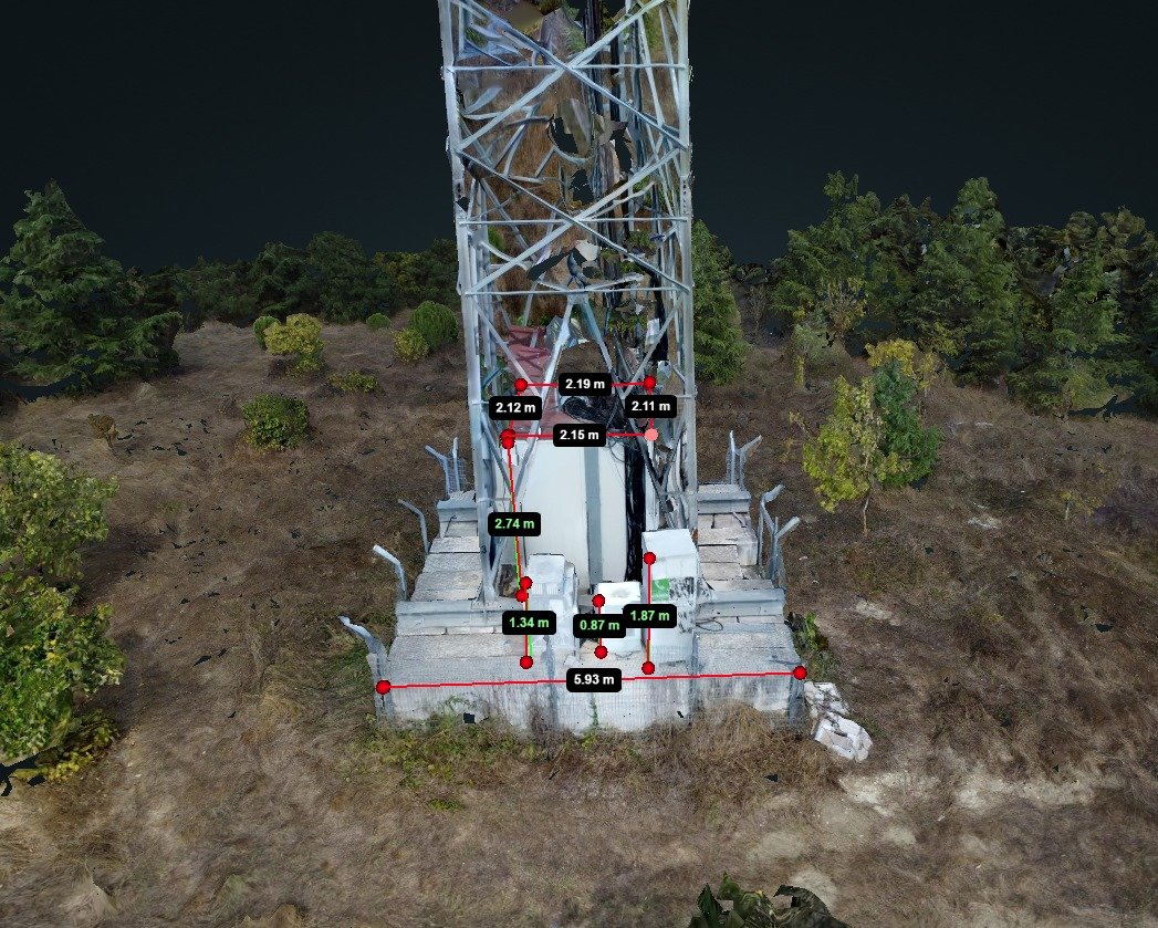
Manual telecom tower inspection requires engineers to climb structures up to 100m high — exposing them to fall risk, adverse weather, and equipment hazard. elipptic5G eliminates this entirely.

Our object detection model uses Convolutional Neural Networks (CNN) and Single Shot MultiBox Detector (SSD) algorithms, trained on over 10,000 annotated tower images. It identifies antennas, RRUs, MWs, MHAs, and structural defects with 95% accuracy — and documents them in a structured report automatically.

The autonomous 3D survey captures base station coordinates, altitude, antenna CL/UL/BL heights, tower height, and equipment orientation from every cardinal direction — north, south, east, and west.

CNN SSD Algorithm 3D Photogrammetry RTK Positioning Auto-Report SIFT Feature Detection
AI Detection Accuracy
95%
95%
Equipment ID Accuracy
80%
Reduction in Manual Work
10k+
Training Images
360°
Site Documentation
Autonomous 3D tower survey — AI identifies antennas, RRUs, MWs, and structural data, auto-generating a full inventory report.
Environmental

Fire & Smoke Detection — Real-Time

Wildfires and industrial fires escalate within minutes. Conventional detection — ground sensors, manned aircraft — cannot respond fast enough across large areas. elipptic5G provides continuous aerial surveillance with immediate AI-powered detection.

Our fire detection model uses CNN and SSD algorithms trained on over 15,000 annotated fire and smoke images — across daylight, low-light, and high-contrast backgrounds. The model identifies both early-stage smoke and active flame at a detection accuracy of 97%.

Integration with live 5G streaming enables immediate transmission of detected events to control rooms, reducing response time by up to 70% versus traditional monitoring.

CNN SSD Algorithm Real-Time Detection 5G Streaming Thermal Compatible
Fire Detection Accuracy
97%
97%
Detection Accuracy
70%
Faster Response Time
15k+
Training Images
Live
5G Alert Streaming
CNN/SSD fire & smoke detection at 97% accuracy — real-time alerts transmitted live over 5G from altitude.
Utilities

Powerline Inspection & Infrastructure Survey

Power line inspection across hundreds of kilometres of transmission corridors is one of the most dangerous and expensive maintenance tasks in the utilities sector. Helicopters are costly; ground crews are slow and limited.

elipptic5G's powerline segmentation model uses the U-Net architecture — specifically designed for dense prediction and pixel-level segmentation tasks. Trained on 12,000+ annotated aerial images, it achieves 93% segmentation accuracy and identifies sagging lines, vegetation encroachment, hardware failures, and clearance violations.

The same platform is applicable to pipe investigations, photovoltaic array inspection, and wind turbine health checks — all deliverable from a single drone deployment.

U-Net Architecture Pixel Segmentation Orthomosaic Mapping RTK GPS GeoTIFF Output
Segmentation Accuracy
93%
93%
Segmentation Accuracy
75%
Reduction in Manual Effort
12k+
Training Images
100ha
Per Single Flight
U-Net powerline segmentation — identifies cables, clearances, and hardware anomalies mapped with centimetre RTK accuracy.
Surveillance & Smart Cities

Vehicle, Person & Traffic Intelligence

Smart city and security teams need real-time situational awareness across large areas — perimeters, infrastructure sites, borders, event venues, and transport networks. Fixed cameras have blind spots; manned observation is expensive and error-prone.

elipptic5G processes live footage at 30 frames per second, detecting vehicles and persons with 95% and 93% accuracy respectively. The model is trained on over 50,000 annotated images across diverse environments — day, night, urban, and open-area scenarios.

Traffic intelligence adds vehicle counting, speed estimation, congestion detection, and incident identification — enabling authorities to respond faster and plan infrastructure more effectively.

CNN SSD Algorithm 30fps Processing Multi-class Detection 5G Live Feed Speed Estimation
Vehicle Detection Accuracy
95%
95%
Vehicle Detection
93%
Person Detection
30fps
Processing Speed
80%
Less Manual Monitoring
Real-time aerial vehicle and person detection at 30fps — live intelligence streamed to command and control via 5G.
Agriculture & Environment

Precision Agriculture & Environmental Monitoring

Modern agriculture demands precision — the right intervention, at the right location, at the right time. Satellite imagery lacks resolution; ground scouting is too slow and impractical at scale. elipptic5G bridges the gap.

A single 40-minute autonomous flight covers up to 100 hectares at 3.5cm ground sampling distance — capturing crop health, nutrient deficiencies, disease signatures, soil variation, and irrigation gaps with sub-metre accuracy.

Outputs include orthomosaic maps, NDVI-compatible imagery, volumetric soil analysis, and detailed environmental monitoring reports — ready for GIS integration.

Orthomosaic Mapping NDVI Compatible 100ha Coverage GeoTIFF / GIS Export 3.5cm GSD
100ha
Coverage Per Flight
3.5cm
Ground Sampling Distance
40+
Minutes Endurance
GIS
Compatible Outputs
Aerial field survey — elipptic5G orthomapping mission
Precision aerial mapping of crop health, nutrient deficiency, and soil variation — 100ha per autonomous flight at 3.5cm resolution.
Construction & Mining

3D BIM, Progress Monitoring & Volumetric Analysis

Construction sites are dynamic, dangerous, and difficult to monitor comprehensively. Stakeholders need accurate progress data, safety compliance evidence, and volumetric measurement of earthworks and stockpiles — all in near-real-time.

elipptic5G delivers automated 3D BIM (Building Information Modelling) updates, stockpile volume measurement via DSM computation, and live 5G streaming for remote project stakeholder visibility. Demonstrated at NEOM, Saudi Arabia, for the British Embassy.

For mining operations, volumetric analysis enables accurate stockpile inventory, blast pattern assessment, and slope stability monitoring — reducing the need for manual survey teams in hazardous zones.

3D BIM Modelling DSM Volumetrics Live 5G Stream H&S Inspection Multi-Object Detection Progress Reporting
3D
BIM Model Output
Live
5G Site Streaming
80
Object Classes Detected
NEOM
Proven at Scale
3D BIM generation, stockpile volumetrics, and live site streaming — proven at NEOM, Saudi Arabia with the British Embassy.

Ready to see elipptic5G
in your sector?

We run customised demonstrations and proof-of-concept flights. Talk to us about your specific inspection challenge.

Request a PoC Demo → View Plans